From 02 February 2026
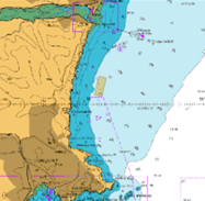
Mariners are advised that installation of special marks will take place at the following positions marking the boundary of Marine Licence L/2025/00300/1:
50°30.7920'N 03°29.5430’W
50°30.2680'N 03°29.7420’W
50°30.2170'N 03°29.4130’W
50°30.7410'N 03°29.2140'W
Or in degree decimals:
50.513200, -3.492383
50.504467, -3.495700
50.503617, -3.490217
50.512350, -3.486900
Installation of mussel aquaculture equipment will take place inside the boundary of these coordinates following this date.
Mariners are advised that these may post a snagging hazard to nets, lines, trawls or other underwater apparatus that is towed or placed near or on the seabed and should avoid underwater operations in the vicinity of these positions.
Nick Burns.
Harbour Master


Delivering Harbour, Beach and Marine Services for Torbay Council.